

There’s more to biking Martha’s Vineyard than sporting a polo shirt as you pull up to a docked super yacht. In fact, serious cyclists are quick to trade sand for concrete at this surprisingly sweet biking destination.
The Massachusetts island is bike friendly; winding roads and bike paths are accessible and easily linked together for longer, challenging rides. Whether you are looking for a casual spin with the family or a 60+-mile loop, the calm weather and stunning scenery of “The Vineyard” smooth the road ahead.

Approximate Distance: 12 miles
This isn’t exactly Le Tour de France. A mellow 6-mile trip (12 miles out and back) meanders down MV’s iconic eastern coastline. Pick your way through town, follow signs to the beach and enjoy the paved bike path that parallels Beach Road. The path dips south down a narrow spit of land, flanked by sweeping ocean and a picturesque lagoon.
Flip Stop: On Beach Road, a bridge straddles the channel where the lagoon and the ocean meet. You’ll hear whoops and watch teenagers flip into the salty currents. Spectate or join in; your bike shorts will dry soon enough.

Approximate Distance: 28 Miles
A solid loop for beginner/intermediate cyclists, this one can extend for a more significant ride. From Tisbury, follow the path south along Edgartown-Vineyard Haven Road. Signs point you to popular hangout, Katama Beach, ten miles south of your launch point.
At Katama, pedal west, parallel to the beach, before banging a right on Herring Creek Rd. Once back to Edgartown, turn left on Edgartown Road (not to be confused with Edgartown-Vineyard Haven Road). Enjoy scenic miles on the southern outskirts of Manuel F. Correlus State Forest. Hug the Park and then take a right on Old County road. Pedal hard on a straight shot back to Tisbury.
*Note: Here are a couple of our favorite extensions for this loop:
State Forest on Martha’s Vineyard?
Manuel F. Correlus is a lush 5,343-acre park. A valiant effort to save the peculiar, now extinct, Heath Hen (subspecies of the Prairie Chicken), the park offers the best trail running on the island.

Approximate Distance: 37 Miles
Climbing Time: Most of Martha’s Vineyard is flat as a piece of salt cod. Imagine the southwestern corner of Aquinah the fish’s tail, crumpled and curled up.
From Tisbury, follow State Road or Old County Rd south to West Tisbury. Link up with Middle Road and follow signs to Chilmark. The fun starts after Chilmark – and by fun we mean climbing.
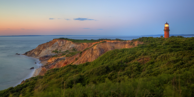
Continue onto State Road and enjoy pedaling gorgeous Gay Head, the southwesterly foot of the island. With Menemsha Pond to the north and Squibnocket Pond to the south, this section of State Road is the most striking part of the ride; second, in fact, only to bit named “Moshup’s Trail.” Turn left on Moshup’s Trail off of State Road (be on the lookout once passing the ponds). To your left, rolling waves crash on white sand beaches, dunes shimmer with windblown grass, cliffs erode into sculptures of sand and stone. Though you may be fatigued after 20 miles, these coastal miles are still the fastest of the trip.
Break the ridge of Moshup’s and join tourists who drove across the island to see the towering lighthouse and the impressive Aquinah Cliffs. Take pleasure knowing that you sweat to see the sights. Once you’ve met your tourism quota, roll north along the Gay Head coast on Lighthouse Road. Follow signs back to Chilmark, then Middle Road to State Road and the home stretch to Tisbury.
Hungry? After your ride, stop at the Net Result for a plate of fried clams or The Art Cliff Diner for their daily special. You’ve earned it.
Triathlete Training Tip: If you’re looking for a more difficult route, this 37-mile jaunt can be extended. We rode with a couple of triathletes who train all summer long in MV and combine route 2 and 3 for a 60+-mile, tip-to-tip ride.
Cover image via Rolf_52 / Shutterstock.com